


River Animator visualization add-on

River Animator is the new RiverFlow2D v4 visualization tool developed by Herrera Environmental Consultants in collaboration with Hydronia.
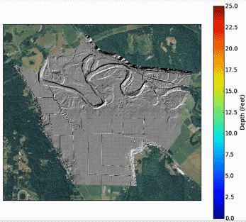
This tool is a standalone software is fully accessible from the RiverFlow2D v4 Data Input Program and allows generating animations of RiverFlow2D model results in Windows Media Viewer or Google Earth. Capabilities include:
- Projection from XY coordinates to latitude and longitude (no need of other GIS program)
- Animation of results or static images with date stamp, depending on number of time steps
- Visual quality assurance checks of initial model runs
- Model results instantly superimposed on familiar Google Earth maps
- Show water surface elevation, depth, or bed change, with or without velocity arrows results animation in WVM files
